Arkansas River Basin Salinity Mapping
Salinity Mapping for the Arkansas River Basin in Colorado
Introduction
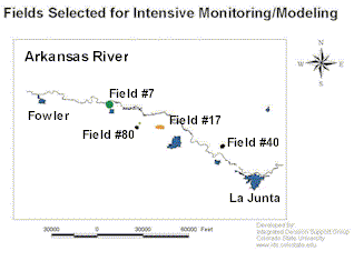
About 30 percent of the land in the western United States has a moderate to severe potential for salinity problems (Nation Research Council, 1996). Colorado's portion of the Arkansas River Basin contains crop lands with salinity problems. The location of the study area for this project is shown in Figure 1.
Select Locations to View Salinity Maps and Animated Movies
- Field #7
- Field #17
- Field #40
- Field #80

Monitoring Locations along the Arkansas River
Where salinity problems occur, the productivity and sustainability of agricultural communities are diminished (Western Water Policy Review Commission, 1997). Sustainable agriculture is defined as being productive and profitable while also conserving resources, protecting the environment and enhancing the health and safety of the public (O’Connell, 1991). While problems of salinity have been addressed by the agricultural community for many years, the inability to achieve sustainability in areas prone to saline problems reflects lack of a more integrated/holistic approach to solving the problem (Water Environment Federation, 1992).
The increased pressure to apply the Total Maximum Daily Load (TMDL) requirements of Section 303(d) of the Clean Water Act to agricultural operations highlights the need to quantify the ability of various Best Management Practices (BMPs) to reduce pollution loadings from agriculture. This research is designed to help in the field scale mapping of salinity in the Arkansas River in southeastern Colorado where salinity levels of the canal systems along the river increase from 300 ppm total dissolved solids (TDS) near Pueblo to over 4,000 ppm at the Colorado-Kansas border.
Salt concentration is significantly increased by consumptive use due to human activities. Consumptive use alone causes a seven-fold increase in the salt concentration in the Arkansas River (USGS, 1997). Evaporation from reservoirs, canals, high water table areas, and from cropland receiving excessive amounts of irrigation water or poorly timed applications are important consumptive uses. Evapotranspiration also occurs from crops and weeds and from phreatophytes in waste water areas.
In some areas, crop yields are being reduced and land is being lost from crop production because of high salinity levels. As a result, there is a need to blend improved yielding capabilities, crop types, economic returns, irrigation practices, and water quality concerns into a complete management package that can be used by agricultural producers. The first step in this process is determining the status of salinity at the regional and field scale. A general map is shown below which gives the location of four fields on which currently spatial and temporal data is being collected.
Data collection
Water Table (Depth and Salinity)Depth to the water table is being collected from observation wells that have been drilled in each of the fields. Between 7 and 11 observation wells are currently being monitored in each field. The location of the wells in each field are shown for each field. The locations of the wells were obtained using a deferentially corrected GPS. Using the GPS, the location and elevation (with an accuracy of a few centimeters) was obtained. The depth to water table has been collected at some of the observations wells every hour using a continuous water table recorder as well as weekly manual observations. The salinity of the water table is measured manually each week. Maps showing the weekly spatial variation in depth to water table and groundwater salinity have been generated. The set of weekly figures showing the depth to water table have been combined into a movie allowing us to view not only the spatial variation but the temporal variation as well. A second movie has been generated showing the temporal and spatial variation in the groundwater salinity.
Soil Salinity
The soil salinity measurements were done using two different instruments that use the principle of electromagnetic-induction to determine the soil salinity. The first instrument is a hand-held unit called an EM-38. In order to use the reading generated with the EM-38, we collected both the EM-38 reading and at the same time a deferentially corrected position. The grid at which data was collected for one of the fields can be viewed in figure 1. The data collected from the EM-38 has been processed to obtain soil salinity from the EM-38 readings. The second method that was used to obtain soil salinity data involves a trailer fitted with electromagnetic sensors (Veris system). The trailer is pulled with a truck that contains a differential GPS unit. The sensor sends readings every few seconds. These readings are combined with a differential GPS signal to generate the maps. At the present time research is being conducted to obtain calibration curves that will allow for the development of soil salinity values from the electromagnetic readings.
Spatial and Temporal Correlation of Data
The information collected for depth to water table, groundwater salinity and soil salinity is currently being analyzed. One analysis that is being conducted with GIS is to determine if there is spatial and/or temporal correlation between the soil salinity, depth to water table and/or groundwater salinity.
Summary
We anticipate that we will continue to collect data for another two years. The ability of GIS to display the spatial and temporal variation of the data and the ongoing research on the correlation of the different data sets will help us understand the salinity processes and to find patterns that occur in the data measured.
Power Point Presentation
Download the zip file of a power point presentation.


